Sunday, October 23, 2011

Confessions of a Bike Commuter

A customer from Los Angeles called me the other day, "Rusty, I'm going to buy you a bike helmet!"  Well, I have a helmet, but thanks.  Apparently a colleague mentioned to this customer that I bike to work.  "Are you serious?  How can that be?"  Customer was beside himself.  This is a guy who wakes at 3 AM to make it to work by 8:30.  Biking?  Inconceivable!

I confess, I am a bike commuter.

Since my son first started day care, I've taken him in the morning, and my wife has picked him up in the afternoon.  This year, he started at our neighborhood school. For years we told him that he would walk to the big kid school one day, and that day arrived this August.  He loves the walk, and it was just the excuse I needed to try bike commuting.  I've been biking like a fiend for over a year, I took the 2 mile pledge, and here was my chance to more fully integrate the bike into my daily schedule.

Back to my LA customer. He asked:
-How far?
Depends.  Straight shot in a car is about 2 miles, but I take alternate routes to avoid high traffic and hills.  The most direct route I bike is 3.5 miles, but I'm developing an addiction to West End Coffee from the Swamp Rabbit Cafe, and with that detour, it brings my commute to 6 miles.  With the coffee stop, that's still only 40 minutes at a very comfortable pace
-Do you break a sweat?
Yes I do. August and September especially, but after a couple of months, I've developed some tricks.  I bike in a wicking shirt and carry a change in my saddle bag.  I've also stashed a couple of extra shirts and pairs of socks in my office.  Tender Fresh Bath Wipes are a giant wet wipe designed for camping, and they work incredibly well.  I order from Amazon and have them shipped directly to the office.
-Is it safe?
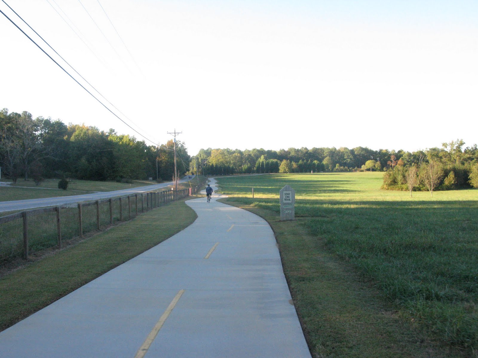
I hope so. Biking infrastructure in Greenville is respectable and getting better. There are some streets I avoid because of high speeds and traffic volume, but I do have access to wide neighborhood roads, a dedicated trail (the incredible Swamp Rabbit Trail,) and bike lanes. I have both tail mounted and front mounted safety lights plus a safety vest and reflective ankle strips.
-What about lunch?
My saddle bag has room for a lunchbox, but I also take advantage of numerous restaurants within walking distance.
-Why Bike Commute?
Biking has just become a bigger part of my life, and I enjoy riding whenever I can.  Sure I'll save money on car expenses, and I'll improve my health, but those are incidental benefits as opposed to motivation. I do love spending a few minutes chatting with neighbors on the way to school as opposed to just the courtesy wave from a passing car. I feel more connected to the neighborhood - you just experience things more deeply walking or biking as opposed to speeding in a car from point A to B.

Sounds easy, right?  In some ways it is, but I'm fortunate to live close to work and biking facilities.  I love my morning ride and feel a little grumpy those days I take the car.  It's certainly not for everyone, but if you're even remotely thinking about it, give it a shot.  Make it a special one day treat and just see what happens.

And if you're read this far, I owe you my deepest confession: The hardest part is stopping at work!


Hope to see you out there!

Packed and Ready

2 Mile Challenge

Trek's 1 World, 2 Wheels

The Swamp Rabbit Trail

Swamp Rabbit Cafe & Grocery

Bikeville - Cycling in Greenville,SC

Saturday, August 27, 2011

On Cool Mountain Air, White Squirrels, and Bike Paths

I first discovered Brevard, NC in 1992.  I was a college student in Atlanta with a love of camping and a budding interest in cycling.  A friend took me on a trip to Pisgah forest for mountain biking and camping, and I was hooked.  I've travelled to Brevard somewhat frequently since then.  In the mid 90's, I moved to Greenville,SC and fell into the restaurant business.  Hours were long and days off hard to find, but the 1 hour ride over Caesar's Head to Brevard was enough of an afternoon diversion to clear my mind and recharge my spirit. My wife and I still enjoy trips to the mountains.  We've developed a standard Brevard get away that includes lunch on the way out of Greenville, a hike in Pisgah Forrest, dinner downtown, followed by a show at the Brevard Music Center.
I'd heard talk of the Brevard Bike Path for a couple of years, but chatter about it has increased lately, so on a recent sweltering day in a string of sweltering days, I took a half day off from work and headed up the mountain.


I parked at Brevard Middle School just 2 blocks from the trail (and location of the only hill of any significance on the ride.)  I headed out around noon, and true to form, temperatures where in the mid 80's whereas Greenville was low 90s and climbing.   The wide, paved trail started off through a nice garden before paralleling N Broad St/Asheville Hwy. Close to a mile in, the trail turned off to fields, crossed Lamb Creek and came through the Recreation District and the athletic fields (another good parking spot/trail head.) The trail joined up with Ecusta Rd before crossing back over Asheville Hwy and heading into Pisgah Forest at the 3.5 mile mark.  As the trail neared Pisgah, the pavement suddenly ended and turned to crushed stone.  I rode a hybrid, but a street bike would have done well too.  Signs of new and continuing improvements to this section gave hope for an even better trail in the near future.  Boardwalks exist and are being improved over the wet sections along the Davidson River.  I passed several small waterfalls joining up with the river. I've hiked and camped in this area many times, and it's always great to hear the sound of the river, to wave at the trout fisherman, and to laugh with the kids rafting.  Next time, I may bring a swimsuit and a lunch and spend a few hours here!  The crushed stone section runs 1.2 miles before you cross Davidson River, and from there, you're 0.2 miles to more parking at the Art Loebe Trail Head.


I headed back to the car, logging 9.7 miles round trip, swung by Sonic for a Lime Aid and headed back across Ceasar's Head.  Recharged now and looking forward to riding again in Brevard soon.


Notes:
Here's a link to Friends of the Ecusta Trail and the visionaries planning a rail to trail conversion linking Hendersonville,NC and the existing Brevard Greenway Trail. The basic infrastructure is in place to make the Ecustra Trail a destination ride like the Silver Comet in Georgia or the Swamp Rabbit Trail in Greenville,SC.  People already look to Western North Carolina as a vacation spot, and restaurants, camping, hotels, and shops are in place to support riders.  I'm excited and hopeful to follow this project's implementation. 


White Squirrels are part of Brevard's lore, and here's a little story behind it.  About White Squirrels  I officially move to rename the Brevard Bike Path the "White Squirrel Greenway."  Sexy, isn't it?  Think of the merchandising potential.  Animals sell Brevard, make it happen! 


The ramblings here are based on a June 15, 2011 ride.


Trail Link Post on The Brevard Bike Bath

Ceaser's Head State Park

Brevard, NC City Page

Mountain Biking in Pisgah Forest

Crushed Stone in Pisgah Forest


Through Athletic Fields Near Ecusta Rd

Along Hospital Rd

Trail Head at Poplar St (near Brevard Middle School)

Saturday, August 6, 2011

Augusta Canal Trail - Poor Decisions,Poor Planning

An e-mail popped up a couple of weeks ago from a good friend and riding partner. He's a teacher, was about to head back to class, and wanted a good weekend ride before the semester.  I told him about the North Augusta Greenway and how much I enjoyed. I also related my desire to cross the river and try the Augusta Canal Trail.  I scouted it before but had trouble actually getting to the actual trail.  I've resolved for months to get on it, and this was my excuse.
My friend is a man of some standing in his community and probably wouldn't appreciate me using his real name; therefore, in this ramble, he'll be know as Trident.
Trident headed to North Augusta,SC Saturday and rode the Greenway.  Not being a teacher with a summer of leisure at my disposal, I was unable to break away from adult responsibilities until later Saturday evening.  I met Trident at the Augusta Green Jackets Stadium, home of the defending World Champion San Francisco Giants' A affiliate of the South Atlantic League. Over a beverage, Trident confirmed his enjoyment of the North Augusta Greenway. Not much baseball was watched, but we did enjoy the opportunity to soak through out shirts in the oppressive humidity while also people watching (it was "Halloween," and the staff and many fans went all out on costumes.) Being completely dehydrated and knowing we had 20 miles of riding in high 90s heat the next morning, Trident suggested hitting Wild Wings for a spicy late night snack. To help digestion and prepare for the morning ride, Trident further pushed a cooler of assorted beers (Smithwicks,Yuengling,Budweiser) and the idea to catch up and have a good chat until 1 AM.  Six hours of sleep should be plenty.
Sunday morning over Bojangles biscuits, we finalized our strategy.  Maps at the ready, we programmed the GPS and headed for Eisenhower Park.  Despite the GPS's insistence that the park was accessible from the Parkway, I believe Michael Stipe knows better :"You Can't Get There From Here."  Luckily my inner Boy Scout kicked in, and we back tracked through some neighborhoods to find the park.
We found cars with bike racks but no trail.  Undeterred, we pushed to the sound of water and found a sign
The sign did say welcome, although neither Trident nor I felt that sentiment.  Undeterred, we found a side path  through the grass and pushed onward.  After a couple hundred feet of incredibly rough gravel (your bike mechanic will love you if you actually ride this section,) we came to a cool scene:
Alright. Bridge, Pumping Station, Trail.  Giddy up!  Let's Ride!!!

We joined the trail around the 4 mile mark and headed south to downtown.  The pavement ended rather quickly and the route turned into a dirt road paralleling the canal.  Surface was good though and we pushed south.
After a mile or two, we started up another round of find the trail, lose the trail which would continue for the next couple of hours.  Trail markings were poor, and even with the help of some friendly locals, we became lost quite a bit.  Luckily, we could always keep the canal in sight and follow the water into town (There's a lesson here for the Blair Witch Project cast.)
But to focus on the positive, here are some of the cool sights along the way


Frustrating losing the trail, but nice scenery.  Closer into downtown, the trail is paved for a bit, then it takes to the city streets.  We rode on a Sunday morning, and the roads were empty.  Just riding around town would have been a fun morning ride, and we did take a slight detour off the trail to explore the city.

The Trail ended at the Augusta River Walk http://www.augustariverwalk.com/

We did better heading back up the trail, although we still lost if from time to time.  We discovered that there were signs, but they were often small or covered by weeds.  We passed our original entry point and pedaled to the northern terminus.  I really liked this section.  The dirt road continued for about 4 miles along the canal, and despite the rising heat, the shade and coolness from the moving water helped keep us comfortable.  As the canal came closer to its merging with the Savannah River, we were able to see the river on our right.  The rocky, quickly moving Savanna was a nice contrast to the slow moving, peaceful canal on our left.  The northern end at the locks is really nice and appears to be where the activity is.  The park is beautiful and reports indicate bike trails continue away from the river for several miles.  We looked around the park, but because of the emerging hills and questionable decisions Saturday night, we opted to head back to the car.  Hey, it was about lunchtime.

Here are some views of and around the locks


A couple of shots of the trail heading inland from the locks


Trident and I didn't have a good taste of the trail after the ride.  The lack of markings and quality of the surface was disappointing and frustrating.  We both live and ride in areas where there are solid, paved trails in vibrant communities that have a strong economic base and community commitment.  I didn't get that feel in Augusta.  Unfortunate, because looking back, there are some nice features of this trail.  A Kroc Center is opening downtown and could be a good base for future rides.  The markings are there if you know where to look, so get some local help if you decide to ride.  Starting at the Locks is another good option.  Have some fun on the dirt, if it's dry, the surface is just fine.  Take in the history and industrial charm, appreciate the water and birds.

If you see this, don't dismiss it, this is actually a trail, but only a small sample of what you'll see on the canal.
Anticipate  the nicer sections


The canal web site breaks down the different trail sections and has good information on entry points
Augusta Canal

Trail Link Entry for Augusta Canal Trail

Sunday, May 29, 2011

On Two Wheels…The Sights from the Azalea City Trail

On Two Wheels…The Sights from the Azalea City Trail


by Ben Pitchford
Guest Blogger

Pedaling the Valdosta, Georgia’s Azalea City Trail on a May afternoon with temperatures expected to reach triple digits, I had a song that I just couldn’t get out of my head. Robert Earl Keen, talking about the sizzling heat of Arizona, nasaly croons “You can fry an egg out there on the city sidewalk.” A fitting song for this south Georgia scorcher. Sure it would have been more comfortable to travel around town in my car with the air conditioner running full blast. But if I had chosen that mode of transport over my bicycle then I probably wouldn’t have gotten to see the kid in the cul-de-sac trying to fry an egg on the black asphalt. If he had heard my 4000 pounds of German engineering made in Mexico City barreling down his quiet street, he would have scurried to the safety of his yard waiting for me to pass by. From the comfort of my car I never would have seen the yellow yolk sitting atop the black asphalt. The vantage point from my bicycle not only allowed me to see the boy’s experiment in thermodynamics, but allowed me to see so much more.
Driving by at 35 miles per hour with the windows rolled up and the radio on I would have missed the boy’s expression of impatience. The egg was just not frying fast enough for a 10 year old expecting everything to be done at warp speed. I too am accustomed to everything being done instantly, so cruising by on a bicycle helps me to slow down and take it all in. I didn’t smell any roses on the trail today but I did slow down enough to notice that there is more going on along this 2.7 mile trail than I would have ever realized had I driven the same distance in my car.
The Azalea City Trail meanders through Valdosta passing by residential areas, two parks, and the edge of the Valdosta State University campus. I started my ride at my house and pedaled about a mile and half to the eastern end of the trail. I rode the length of the trail and back and then added another mile and half in the neighborhoods between my house and the trail and rode a few more miles in the neighborhoods adjacent to the trail. Only a half mile into the trail I came across an unexpected sight in the large open field of Vallotton Park. While football is king in these parts, cricket apparently is trying to establish itself here. A large group of Indian cricket players, some dressed in the traditional all white uniform, spend Sunday afternoons at Vallotton Park playing their favorite sport. The gyrating motions of the bowler, the swinging of the bat by the batsmen trying to guard the wicket, and the chatter of the fielders in a language I do not understand makes for quite a unique spectacle.
About half way along the trail is beautiful Drexel Park which is full of azaleas and large shade trees. The trail runs along the edge of the park where a group of medieval re-enactors, dressed for the part, where gathering to do battle medieval style. At the other end of the park birds chirped and children laughed as they played chase and swung in the swings. Drexel Park led me onto the Valdosta State University campus. The trail runs along the edge of campus but it’s enjoyable to hop off the trail for a spin through the heart of campus. Lush lawns, Spanish mission style architecture, fountains, and large oak trees provide a beautiful back drop from atop a bicycle that motorists zooming down Patterson Street often fail to notice. After riding through campus the trail traverses a wooded area with a babbling brook providing a soothing symphony for the rider.
Slow down, take your time, enjoy the sights, listen to the sounds, and say hello to the kid frying an egg on the street. This is hard to do from behind the wheel of our cars. Just getting out of our cars, which we are often so attached to and dependent upon, and taking in the sights and sounds from a slower pace atop a bicycle makes for a nice ride on the Azalea City Trail. 

A shady spot to relax on the Valdosta State campus

Cricket Players at the trail adjacent Vallotton Park

Friday, May 27, 2011

Ecusta Trail - Western North Carolina

Check out the site below.  Our friends in Brevard and Hendersonville are getting a rail to trail conversion off the ground.  Best of luck guys!  Can't wait to ride with you.

http://www.ecustatrail.org/

Sunday, May 22, 2011

Pinellas Trail 4-29-11

Ms.Rusty and I were in Sarasota for a family wedding (Best wishes to Jake and Libby!) I've heard nothing but great things about the Florida trail system, so I spoke with the guys at Chain Wheel Drive in Clearwater and arranged a couple of bike rentals.  Rod set us up with some nice Specialized hybrids and pointed us to the Pinellas trail. (Ms Rusty's rental was better than her own bike. I talked to Steve at The Great Escape this week, and I think she'll be upgrading soon.) The Rails to Trails Conservancy awarded a Hall of Fame designation to the Pinellas Trail, and I can see why.  Trail was flat, wide, and long.  We rode 20 miles and saw maybe 8 miles of the trail. We rode by a spring training baseball stadium, cruised by scenic creeks, detoured to world famous Honey Moon Island, and along the way fell in love with Dunedin, FL. The trail ran right through downtown Dunedin where the old rail station serves as a coffee house. Within blocks were a Jamaican restaurant, American Legion,  brewery, pizza joint, barbecue shack, hotels, shops, and tons of outdoor seating.

I'm told the southern portion of the trail is urban while north of honeymoon is more rural.  The link below is a great resource for maps and amenities.  I can't wait to go back and ride the entire trail!

I'd love to hear from anyone familiar with the trail.  Your pointers will help me plan my next Florida ride.

http://www.pinellascounty.org/trailgd/


Chain Wheel Drive - Bike Shop
Chain Wheel Drive was a serious bike shop, and there were quite a few smaller bike rental outfits along the trail

Dunedin, FL Visitor's Site


Here are some pictures from our ride north of Clearwater to Honeymoon Island.


Tuesday, April 26, 2011

Cold Lemonade and a New Look for Alley Kat's Waterin' Hole


I logged my 20 on the Swamp Rabbit Trail last night, but I made sure it was an easy 20 with several stops along the way.  I visited with the folks at Alley Kat's Waterin' Hole for a few minutes.  They were in the middle of painting a brand new stand, and I didn't want to keep them from their tasks too long.

Alley Kat's sits on the Trail just  north of Sulphur Springs Road, and you'll find it open most Saturdays during warm weather.  My trusty Camelbak is a lifesaver, but there's some days when water just won't cut it.  Enter Ally Kat's homemade lemonade.  When you're our on the Swamp Rabbit Trail, bring a few dollars cash with you and take advantage of this great little rest stop.

Bonus:  Alley donates a portion of her proceeds to the Shriners Children's Hospital.

Shriners Hospital for Children (Greenville, SC)


Hincapie Sport's blogged about Alley Kat's last year - Check it out for more good background
http://blog.hincapie.com/post/Alley-Kats-Waterin-Hole.aspx

Tuesday, March 22, 2011

Catawba River Greenway

Last Saturday (3/12) my wife and I attended a party in Asheville, NC.  We stayed the night, and drove over to Morganton,NC Sunday morning to try to Catawba River Greenway.
I have a subconscious definition of a greenway and I've considered how to express that over the last couple of days. I referenced Webster's and wasn't thrilled with their definition, but still, I haven't been able to perfectly articulate mine either.  So even though I don't have a perfect, concise definition, I know what a greenway is, and when I rode the Catawba River Greenway, I knew this epitomized the greenway concept.  I enjoyed hopping on the trail by a restaurant and boat ramp, riding along the river, through the woods, past the sports fields, back along the river past the overlooks, past more fields, through downtown's river walk, and up to the river and woods again. But, how much better is it for the locals who can walk from their softball game down to the park for a picnic?  Or the parents attending soccer and t-ball games, then walking to the river walk for dinner?  Or the people nearby who want a safe, accessible natural space for a little exercise? The Catawba River Greenway is done right.

Specific to our ride:
We started at Judge's by the River on the south end of the Greenway.  We logged 4 miles to the north end.  Trail was wide (`8ft) and well maintained.  Mostly flat with just a few hills approaching the north end.  Judge's had outdoor seating on the Catawba and from the smell, amazing pork barbeque.  We weren't hungry for lunch, but Mrs Rusty has eaten there before and gives it the blue star seal.  There were restrooms at Judge's and at the adjacent ball fields.  More restrooms, water, and Coke machines are on the river walk downtown.  The river walk also hosts another restaurant with outdoor seating, I believe called Friday Friends.  We rode up and back, took the loop around the ball fields, then took the Freedom Park spur (slight hills) which put us at 10 miles for the day.  We found abundant rest stops along the way - benches and  picnic tables.  We really like this ride and will hit it again if we're in the area. We may even bring a canoe and doing a little exploring of the river.  Not enough distance to recommend a long road trip, but if you're close to Western North Carolina, check it out.


Judge's

City of Morganton Website, Catawba River Greenway

Google Map of Catawba River Greenway

River Overlook

Disc Golf Course on the Right


One of Several Converted Railroad Bridges

Sunday, February 13, 2011

Potty Talk

Let's face it, if you're out on the trail for any length of time and being a good sport about staying hydrated, you're going to hear nature's call.  Here are five main public restrooms along the Swamp Rabbit Trail that I can count on to be clean (and usually open.)


 - Entrance to Greenville Zoo in Cleveland Park
 - Falls Park Downtown Greenville (Below Overlook Grill)
 - RiverPlace Downtown Greenville (Behind O-Cha Tea)
 - By the lake at Furman University
 - The Cafe at Williams Hardware in Downtown Traveler's Rest

Also, remember the many restaurants and shops near the trail.  Most will be glad for you to stop in.

Sunday, January 16, 2011

On the Swamp Rabbit - Day 6 after Winter 2011 Snow In


7 inches of snow fell in Greenville last Monday.  Schools were closed all week, and most of us were experiencing severe cabin fever.  Temperatures hit 50 yesterday, and I hoped the Swamp Rabbit Trail would be passable today.  In most cases it was, but there was still a lot of snow on the ground.  I picked up the trail around 10:30.  Here are some pictures.

Google Map of Swamp Rabbit Trail

I picked up the Rabbit at Cleveland Park (near the Zoo)
Uh oh
Heading South in Cleveland Park(Dog Park Coming Up on Right)


Slick.  Bridge on Hincapie Path Near YMCA

Approaching Farris Rd. I turned around here and headed North

Rough Patch for several hundred yards (along the Reedy paralleling Ridgeland Dr)


New Bridge Leaving Cleveland Park (Before Maj Anderson Memorial)


Obligatory shot of Liberty Bridge at Falls Park. Trail was clear through downtown


Heading north from Linkey Stone Park.  Trail wasn't as bad as it looks.  Slushy and melting fast

Willard St crossing at Greenville city limit
North toward the W Blue Ridge crossing


Between Blue Ridge Dr and Sulphur Springs Rd.  Lots of snow but  nice clear grove for riding

Swamp south of Watkins Bridge Rd
All Clear Rolling into Furman


Behind Furman - I'm Melting!


Near Duncan Rd
Made it safely to Traveler's Rest

And now this traveler will rest.  Enjoyed 2 glasses of tea and a phenomenal  meat loaf sandwich at the Cafe at Williams Hardware
Link to Cafe at Williams Hardware Site